
Garmin zūmo XT2
by Garmin
Original price
$799.99
-
Original price
$799.99
Original price
$799.99
$799.99
-
$799.99
Current price
$799.99
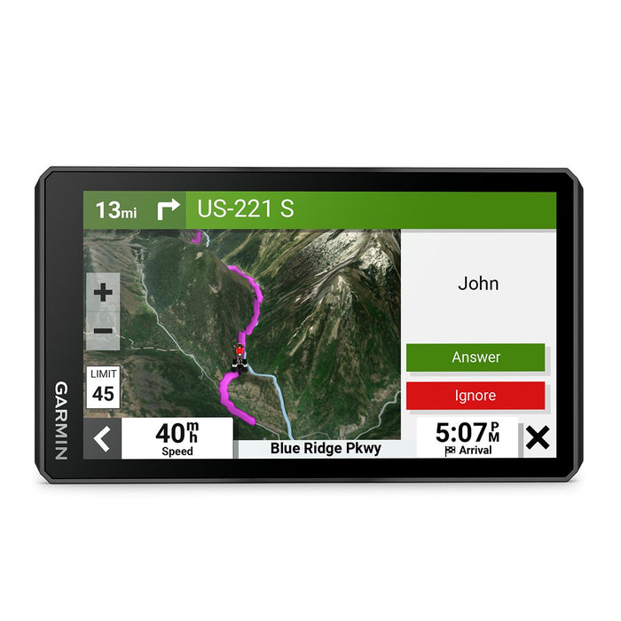
6.0" Motorcycle Navigator
You need throttle therapy. The zūmo XT2 motorcycle navigator is your prescription to hit the road, no matter where it goes. The bright 6” display is glove-friendly and packed with features to help you find the perfect motorcycle route.
Details:
- Outdoor recreation
- Point-to-point navigation
- Preloaded topographical maps
- Navigate-a-track navigation
- Camera features
- Backup camera compatible (bc™ 50)
- Navigation features
- Visual route planner
- Garmin real directions™ landmark guidance
- Tripadvisor® traveler ratings
- Route shaping through preferred cities/streets
- Includes traffic (with Garmin tread app)
- Lane assist with junction view (displays junction signs)
- Bluetooth® pairing (works with Bluetooth-compatible helmet, headset or smartphone. Ble capable.)
- Speed limit indicator (displays speed limit for most major roads in the u.s. And europe)
- Driver alerts for sharp curves, school zones, red light and speed camera warnings and more
- Advanced features
- Smart notifications via app
- Wi-fi® map and software updates
- Access to live services via app (traffic, weather, etc.)
- Motorcycle features
- Control music and media from smartphone or mp3 player
- Sunlight readable and weather resistant
- Garmin adventurous routing™
- Rider alert warnings for sharp curves, state helmet laws, speed cameras and more
- Planned & dynamic fuel stops
- Popular paths (moto)
- Elevation profile
- Round trip routing
- Track support
- Custom map support
- Wireless ant+® technology
- Adventure features
- Pair with compatible inreach® devices
- Pair with garmin powerswitch™ digital switch box
- Compatible with group ride radio
- Group ride mobile
- Track recorder (breadcrumbs)
- Compatible with the garmin tread app for route planning and data management (waypoints, tracks, and routes)
- Ultimate public campgrounds
- Birdseye satellite imagery (download via wi-fi)
- Glove-friendly touchscreen